Geographical Information and Communication specialist AfriGIS has announced the long awaited release of the AfriGIS Telecoms Market Share - and AfriGIS Movement Insights Databases.
In business it is critical to identify what your market share is in a specific area and- or how customers move past your physical distribution network. This has been the elusive mystery countless studies aim to prove on an annual basis.
The dataset is derived from hundreds of millions of samples and a constant real time feed of location relevant information providing unrivalled insights into customer movement behaviour and the telecommunication coverage environment in which it takes place.
With the AfriGIS Movement Insights Database (Might-D) you can get a view on the most prominent intersections in a specific area, based on real time, anonymous measurements from AfriGIS's Smartphone software installed on over 200 thousand devices countrywide.
Some of the major Trade Area Analysis benefits it empowers you with:
- identify gaps in your retail network and areas where you are over or under represented, by viewing the data in mapping tools
- add your own data
- review your distribution strategy in terms of the volume of traffic and congestion in certain areas
- Monitor your outlet performance by index against demographic and movement information
- Maximise your advertising exposure
AfriGIS believes that the future of geographical data lies in the combination of massive datasets which are then analysed and depicts trends locked up in the picture they jointly illustrate.
A practical and very insightful example of this, produced by the AfriGIS specialists are the combination of movement data and the National sample on Mobile telecoms market share. The National sample was a by-product of the Census Progress Watch initiative, awarded a Highly Commended Award, at the 2012 AfricaCom Awards in Cape Town.
AfriGIS is also busy integrating Census 2011 results into the data to normalise and evaluate the story it tells, with subsequent exciting outputs. The dataset allows the sensible analysis of various groups of millions of data points to answer questions such as:
- Where are my customers?
- Specific points they navigate past and at what speed?
- How many customers are there?
- Start and end travelling patterns, to name but a few.
For telecommunication role players the datasets answers critical questions, such as quality of the data network, coverage information and improvements of data quality in a specific geographic area. The dataset provides daily or monthly views on how the user experience of the data network has improved and which network has the best coverage in a certain area. The exploration of these performance levels recognise improvement over time or how specific marketing- or technical interventions changed market share and/or network quality.
Charl Fouché, Operational Director of AfriGIS gave a view on the current datasets: "When we first started to see how the patterns emerge by combining the datasets we were really excited. The volumes are of such a nature that they are telling a story worth listening to. We are taking the next step in answering our customers' questions and what to do with those answers, saving them time in getting to the core of their business. Admittedly there are always more variables and volumes that can be added, and certain geographic areas which are under sampled, but with hundreds of millions of samples, collected over the past two years, the AfriGIS team is confident that the new dataset can add value to your current planning and operational processes."
Magnus Rademeyer, Managing Director of AfriGIS concluded with a view of where it will lead to in future: "For customers with their own field force, we are linking the analysis of the data into their own insights captured from mobile devices in the field. They can use their own mobile tools or tap into the products that make up the AfriGIS Mobility Framework, to provide even richer insights through our mobility framework. We are taking those insights through to the operational environment with our routing and scheduling algorithms and real time navigation tools, with real time traffic data provided in partnership with Altech Netstar Traffic. Expect some very interesting developments in the next couple of months."
The pricing of the dataset is based on either the purchase of 'the per-point raw data' or a monthly subscription to the processed data.
See an overview of the AfriGIS Mobility Framework at www.youtube.com/afrigis - AfriGIS Software Enablers & AfriGIS Mobility Framework.
The selected images below indicate:

the sample coverage of the country for a month;
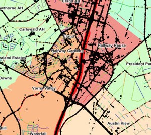
the granularity of the data;
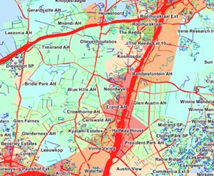
the aggregation of the point data to specific corridors.